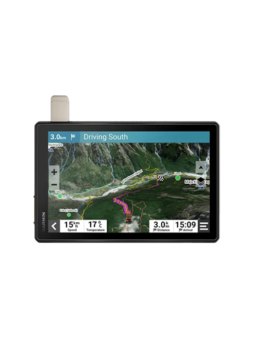
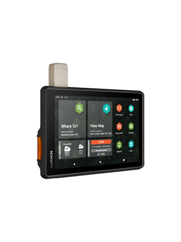
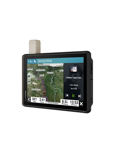

Tread® XL - Overland Edition
10” All-Terrain Navigator
Explore the unknown with confidence. The rugged 10” Tread® XL Overland Edition combines turn-by-turn off-road navigation, vivid satellite imagery, and inReach® satellite communication — keeping you on track and connected, wherever the trail leads.
Description
Key Features
Specifications
Benefits
Built to Explore: Rugged Navigation with Global Connectivity
Built for true overlanders, the Tread® XL - Overland Edition combines an ultra-bright 10” touchscreen with all-terrain durability and advanced navigation features. Access turn-by-turn directions on off-grid trails using OpenStreetMap and USFS maps, and find remote campsites with preloaded iOverlander™ POIs. Its IP67-rated design resists dust and water, making it a reliable companion no matter the conditions.
Stay informed with detailed BirdsEye Satellite Imagery — no subscription required — and keep your journey on track with custom routing tailored to your vehicle’s dimensions. With an active inReach® subscription, you’ll also have global satellite messaging and SOS capabilities, so you're never truly out of reach. Whether you're navigating mountain passes or desert trails, the Tread® XL has your back, from planning to arrival.

| Features |
|---|
| Navigate unpaved roads and trails by using turn-by-turn trail navigation1 with OpenStreetMap (OSM) and USFS Motor Vehicle Use Maps. |
| Custom routing for the size and weight of your rig2 and preloaded iOverlander™ points of interest (POIs) help you find where to set up camp. |
| This rugged navigator is IP67 weather-resistant and has an 10” ultrabright touchscreen display. |
| See vivid aerial views of terrain with downloadable, subscription-free BirdsEye Direct Satellite Imagery. |
| Use the Tread® app on your compatible smartphone to sync data across your various devices and plan routes. |
| Peace of mind comes built-in. With an active subscription, you can use inReach® technology for global satellite communication. |
Physical Specifications
- Dimension: 9.9"W x 7.8"H x 1.2"D (25.2 x 19.9 x 3.1 cm)
- Weight: 32.8 oz (930 g)
- Water Rating: IPX7
- Drop Rating: MIL-STD-810
- Dust Rating: IP6X
Display
- Type: Multi-touch, glass, high brightness HD color TFT with white backlight
- Size: 8.5"W x 5.3"H (21.7 cm x 13.6 cm); 10.1" diagonal (25.7 cm)
- Resolution: 1280 x 800 pixels
- Dual-Orientation Display: Yes
Mounting
- Magnetic Mount: Locking magnet-assisted mount
- Adapter: 1.5" ball adapter with AMPS plate
Battery
- Type: Rechargeable lithium-ion
- Life: Up to 6 hours at 50% backlight / Up to 1 hour at 100% backlight
Maps & Memory
- Preloaded Street Maps: Yes
- High Definition 3D Terrain: Yes
- Preloaded Topographical Maps: Yes
- Preloaded US Public Land Boundaries: Yes
- Preloaded Private Land Parcel Maps: Yes (parcels greater than 4 acres)
- Preloaded USFS Roads and Trails: Yes
- Navigate-a-Track Navigation: Yes
- Turn-by-Turn Trail Navigation: Yes
- Internal Storage: 64 GB
- External Memory: Yes (up to 256 GB microSD™ card)
- BirdsEye Direct Satellite Imagery: Yes
- TOPO Map Support: Yes
- Includes Map Updates: Yes
Sensors
- GPS: Yes
- Galileo: Yes
- Barometric Altimeter: Yes
- Compass: Yes
- 10 Hz Multi-GNSS Positioning: Yes
Camera Features
- Backup Camera Compatible: Yes (BC™ 50)
Navigation Features
- Garmin Real Directions™ Landmark Guidance: Yes
- TripAdvisor® Traveler Ratings: Yes
- Route Shaping: Yes
- Traffic Info: Yes (with Garmin Tread app)
- Lane Assist with Junction View: Yes
- Bluetooth® Pairing: Yes
- Speed Limit Indicator: Yes
Advanced Features
- Smart Notifications: Yes (via app)
- Wi-Fi® Map and Software Updates: Yes
- Live Services (Traffic, Weather, etc.): Yes (via app)
Motorcycle Features
- Music and Media Control: Yes
- Sunlight Readable and Weather Resistant: Yes
- Garmin Adventurous Routing™: Yes
- Motorcycle-Specific POIs: Yes
- Elevation Profile: Yes
- Round Trip Routing: Yes
- Service History Log: Yes
- Custom Map Support: Yes
RV Features
- Specialized Routing: Yes (based on size/weight)
- RV Parks & Services Directory: Yes
- Road Elevations: Yes
- Speed Limit Changes: Yes
- Route Planner with GPX Sharing: Yes
Adventure Features
- Built-in inReach® Technology: Yes (subscription required)
- Garmin PowerSwitch™ Compatibility: Yes
- Group Ride Radio Compatible: Yes
- External GPS Antenna Support: Yes
- External inReach® Antenna Support: Yes
- Group Ride Mobile: Yes (via Garmin Tread app)
- Track Recorder (Breadcrumbs): Yes
- iOverlander™ POIs: Yes
- Ultimate Public Campgrounds: Yes
- Pitch and Roll Gauges: Yes
- BirdsEye Satellite Imagery via Wi-Fi: Yes
- Glove-Friendly Touchscreen: Yes
Outdoor Applications
- Dog Tracking: Yes (with compatible dog track system)
OFF-ROAD RUGGEDNESS
Purpose-built for all-terrain use, this Tread device stands up to anything the elements can throw at it. It’s IP67-rated for water-resistance.
HIGH-VISIBILITY DISPLAY
With its ultrabright 10” glove-friendly touchscreen, the navigator is designed for easy viewing in bright sunlight or pitch dark. It can be mounted in portrait or landscape mode.
TRAIL NAVIGATION
Enjoy turn-by-turn trail navigation for traversing unpaved roads and trails using adventure roads and trails map content comprised of OSM and USFS Motor Vehicle Use Maps.
BUILT-IN INREACH TECHNOLOGY
Built-in inReach technology offers global satellite communication, two-way text messaging, location sharing and interactive SOS (active satellite subscription required).
MAPS ON AND OFF-ROAD
Tread includes preloaded topographic maps with 3D terrain for North and South America. It also includes detailed street maps of North America with custom routing for the size and weight of your rig.
KNOW YOUR BOUNDARIES
Access U.S. public land boundaries for national forests, Bureau of Land Management (BLM), wilderness areas and more. Also, see U.S. private land boundaries and landowner information for parcels greater than 4 acres.
SATELLITE IMAGERY
Enjoy vivid aerial views when you download high-resolution BirdsEye Direct Satellite Imagery directly to your device via Wi-Fi® connectivity, with no annual subscription required.
TRAIL RATINGS
Our growing trail database now includes difficulty ratings for off-road riding areas, where available, across the U.S.
SNOWMOBILE TRAILS
View snowmobile trail content for select areas within the U.S. and in Canadian provinces. This includes snowmobile-accessible locations such as fuel stops, warming shelters, restaurants and more.
OUTDOOR MAPS+
With a paid Outdoor Maps+ subscription, you’ll get ongoing access to a wide variety of additional premium map content. It is regularly updated and delivered directly to your Tread device via Wi-Fi® connectivity.
POINTS OF INTEREST
Tread comes preloaded with iOverlander points of interest and Ultimate Public Campgrounds, so you don’t need a cell signal to route to the best-established, wild and dispersed campsites.
ABC SENSORS
When you’re headed to tough-terrain, the built-in sensors will come in handy — including an altimeter, barometer, compass and pitch/roll gauges.
SECURE MOUNT
Use the included locking magnet-assisted mount to secure the navigator to your vehicle.
GROUP RIDE MOBILE
Track friends from your compatible smartphone or Tread device when you and your friends use the Tread app’s Group Ride Mobile feature.
EASY ROUTE PLANNER
Use the Tread app to easily plan routes with the same maps, vehicle profiles and route preferences that you have on the Tread device.
EASILY SYNC YOUR DEVICES
Use the Tread app to sync waypoints, tracks, routes and collections across all your devices. Easily import and share GPX files, too.
LIVE WEATHER
Weather ahead? Pair your Tread device with your compatible smartphone, and download the Tread app to access live weather, storm alerts, animated radar and more.
CONTROL YOUR ACCESSORIES
Pair Tread with the compatible Garmin PowerSwitch™ digital switch box (sold separately) to enable on-screen control for your vehicle’s 12-volt electronics — light bars, differential locks and more.
GROUP RIDE RADIO
Pair your device with the compatible Group Ride Radio (sold separately) for communication and tracking of other Tread-equipped riders in your group.
TRACK YOUR DOG PACK
Wirelessly pair Tread with select Garmin GPS dog trackers (sold separately) to help track and retrieve your sporting dogs in the field. You’ll see markers for each dog within tracking range, overlaid right on the navigator’s map screen.